我如何将这些多边形元素阵列重塑为多角
我从外部API接收到我放入数组中的多边形。多边形是美国的每个县,因此我对我不感兴趣。多边形阵列还使其将它们加载到我的Web应用程序中,非常沉重和缓慢。然而,我感兴趣的是这些县 - 生产者结合的外部界限。
我希望从ST_GEOMFROMTEXT中制作多重分子或ST_EXTERIORT,但是当我这样做时,我只会在PostgreSQL中出现错误。
以下是多边形阵列的一个示例,我们称其为“多重账户”。我试图做一个st_geomfromtext(乘数),但获取错误:“错误:function st_geomfromtext(json)不存在”(安装了tostGIS,我倾向于将其作为通用错误消息)。
那么,如何在PostgreSQL中将这一大阵列多边形降低到一个多角形呢?
[
{
"type": "Polygon",
"coordinates":
[
[
[
-96.2044982,
44.1972122
],
[
-96.19869990000001,
44.197311400000004
],
[
-96.07869720000001,
44.1966133
],
[
-96.06369780000001,
44.1965103
],
[
-96.06349940000001,
44.182312
],
[
-96.0635986,
44.139911600000005
],
[
-96.06389610000001,
44.11581030000001
],
[
-96.06439970000001,
44.01391220000001
],
[
-96.0641937,
44.000011400000005
],
[
-96.0639953,
43.9501113
],
[
-96.0639953,
43.89161300000001
],
[
-96.0641937,
43.88521190000001
],
[
-96.0641937,
43.87001030000001
],
[
-96.06439970000001,
43.856410900000014
],
[
-96.06369780000001,
43.849212600000016
],
[
-96.07279960000001,
43.84901040000002
],
[
-96.12529750000002,
43.84871290000002
],
[
-96.19999690000002,
43.84871290000002
],
[
-96.23219290000002,
43.84851070000002
],
[
-96.28549950000001,
43.84881210000002
],
[
-96.29159540000002,
43.84871290000002
],
[
-96.30690000000001,
43.84891120000002
],
[
-96.34439840000002,
43.84891120000002
],
[
-96.38990020000001,
43.84931180000002
],
[
-96.39519500000002,
43.849212600000016
],
[
-96.40179440000001,
43.84941100000002
],
[
-96.40569300000001,
43.84931180000002
],
[
-96.45349880000002,
43.84961310000001
],
[
-96.45329280000001,
43.85221090000001
],
[
-96.45329280000001,
43.89121240000001
],
[
-96.45349880000002,
43.89851370000001
],
[
-96.45329280000001,
43.906612300000006
],
[
-96.45339960000001,
43.944713500000006
],
[
-96.4531936,
43.963413200000005
],
[
-96.45339960000001,
43.9738121
],
[
-96.45309440000001,
44.007713300000006
],
[
-96.45339960000001,
44.02461240000001
],
[
-96.45309440000001,
44.04521170000001
],
[
-96.4531936,
44.09291070000001
],
[
-96.45299530000001,
44.111312800000015
],
[
-96.45269770000002,
44.19691080000001
],
[
-96.44499960000002,
44.19721220000001
],
[
-96.42469780000002,
44.19711300000001
],
[
-96.33889770000002,
44.19731140000001
],
[
-96.31189720000002,
44.197513500000014
],
[
-96.28569790000002,
44.19741050000001
],
[
-96.24029540000002,
44.197513500000014
],
[
-96.2044982,
44.1972122
]
]
]
},
{
"type": "Polygon",
"coordinates":
[
[
[
-95.8482971,
44.6307106
],
[
-95.8287963,
44.6308135
],
[
-95.7878952,
44.6306114
],
[
-95.75029749999999,
44.6302108
],
[
-95.68560019999998,
44.6299133
],
[
-95.64429469999997,
44.630413
],
[
-95.60399619999997,
44.6299133
],
[
-95.60389699999998,
44.6157112
],
[
-95.60409539999998,
44.600212
],
[
-95.60419459999997,
44.5641136
],
[
-95.60439299999997,
44.5550117
],
[
-95.60429379999998,
44.5425109
],
[
-95.59489439999997,
44.5422134
],
[
-95.59459679999998,
44.5363121
],
[
-95.59449759999998,
44.530014
],
[
-95.59479519999998,
44.5119133
],
[
-95.59449759999998,
44.5084114
],
[
-95.59459679999998,
44.5003128
],
[
-95.59479519999998,
44.496612500000005
],
[
-95.59439839999997,
44.493911700000005
],
[
-95.59439839999997,
44.472213700000005
],
[
-95.59389489999998,
44.428512500000004
],
[
-95.59409329999998,
44.399414
],
[
-95.59389489999998,
44.355812
],
[
-95.59399409999997,
44.3423118
],
[
-95.59339899999998,
44.2976112
],
[
-95.59329979999998,
44.2545127
],
[
-95.59349819999998,
44.195713
],
[
-95.64389799999998,
44.195110299999996
],
[
-95.68359369999997,
44.195510799999994
],
[
-95.70299529999997,
44.19591139999999
],
[
-95.72369379999996,
44.19591139999999
],
[
-95.74339289999996,
44.19621269999999
],
[
-95.75449369999995,
44.19611349999999
],
[
-95.78009789999996,
44.19631189999999
],
[
-95.80489339999995,
44.19611349999999
],
[
-95.83619679999995,
44.19641109999999
],
[
-95.91689299999996,
44.19631189999999
],
[
-95.94629659999995,
44.19651029999999
],
[
-95.99159999999995,
44.19641109999999
],
[
-96.00319669999995,
44.19661329999999
],
[
-96.04369349999995,
44.19631189999999
],
[
-96.06369779999994,
44.19651029999999
],
[
-96.07869719999994,
44.196613299999996
],
[
-96.07869719999994,
44.233310599999996
],
[
-96.07919309999994,
44.254711099999994
],
[
-96.07929989999994,
44.274810699999996
],
[
-96.07929989999994,
44.3136138
],
[
-96.07909389999993,
44.3363113
],
[
-96.07929989999994,
44.3496131
],
[
-96.07919309999994,
44.3539123
],
[
-96.07929989999994,
44.364311199999996
],
[
-96.07919309999994,
44.39241019999999
],
[
-96.07939909999995,
44.430011699999994
],
[
-96.07929989999995,
44.43311299999999
],
[
-96.07989499999995,
44.45901099999999
],
[
-96.07979579999996,
44.50311269999999
],
[
-96.08020009999996,
44.53941339999999
],
[
-96.08009329999996,
44.54341119999999
],
[
-96.08289329999995,
44.54341119999999
],
[
-96.09299459999995,
44.54411309999999
],
[
-96.09289549999995,
44.58691019999999
],
[
-96.09329979999995,
44.60411069999999
],
[
-96.09289549999995,
44.61581029999999
],
[
-96.09289549999995,
44.63051219999999
],
[
-96.05309289999995,
44.63021079999999
],
[
-96.01219939999996,
44.63011159999999
],
[
-95.99199669999996,
44.63051219999999
],
[
-95.95520009999996,
44.63081349999999
],
[
-95.86939999999996,
44.63091269999999
],
[
-95.8482971,
44.6307106
]
]
]
},
{
"type": "Polygon",
"coordinates":
[
[
[
-97.8511962,
43.8499107
],
[
-97.8278961,
43.8496131
],
[
-97.79010000000001,
43.8499107
],
[
-97.7371978,
43.8498115
],
[
-97.66059870000001,
43.8492126
],
[
-97.63529960000001,
43.8492126
],
[
-97.60919950000002,
43.8489112
],
[
-97.60869590000001,
43.832912400000005
],
[
-97.60889430000002,
43.80101390000001
],
[
-97.60879510000002,
43.76031110000001
],
[
-97.60820000000002,
43.74571220000001
],
[
-97.60729980000002,
43.73531340000001
],
[
-97.60669700000003,
43.71661370000001
],
[
-97.60679620000002,
43.710311800000014
],
[
-97.60639950000002,
43.670013400000016
],
[
-97.60659790000003,
43.65921020000002
],
[
-97.60699460000002,
43.60061260000002
],
[
-97.60719290000002,
43.54261390000002
],
[
-97.60699460000002,
43.51681130000002
],
[
-97.60709380000002,
43.499813000000024
],
[
-97.62599940000001,
43.499813000000024
],
[
-97.63959500000001,
43.49961090000002
],
[
-97.73880000000001,
43.49971380000002
],
[
-97.74639890000002,
43.49961090000002
],
[
-97.75090020000002,
43.499813000000024
],
[
-97.75619500000002,
43.49961090000002
],
[
-97.79199980000001,
43.49951170000002
],
[
-97.90519710000001,
43.49961090000002
],
[
-97.93779750000002,
43.49931330000002
],
[
-97.95800010000002,
43.49941250000002
],
[
-97.96459960000001,
43.49961090000002
],
[
-97.96489710000002,
43.507011400000025
],
[
-97.96489710000002,
43.51341240000002
],
[
-97.96629330000002,
43.57731240000002
],
[
-97.96649930000002,
43.60071180000002
],
[
-97.96709440000002,
43.62971110000002
],
[
-97.96679680000003,
43.644210800000025
],
[
-97.96689600000002,
43.648712100000026
],
[
-97.96649930000002,
43.678413300000024
],
[
-97.96829980000003,
43.75111380000003
],
[
-97.96839900000002,
43.761413500000025
],
[
-97.96819300000001,
43.76681130000002
],
[
-97.96839900000002,
43.77771370000002
],
[
-97.96839900000002,
43.79061120000002
],
[
-97.96809380000002,
43.81261060000002
],
[
-97.96839900000002,
43.81841270000002
],
[
-97.96799460000003,
43.825412700000015
],
[
-97.96749870000002,
43.85011290000001
],
[
-97.95139310000002,
43.85061260000001
],
[
-97.90670010000002,
43.85061260000001
],
[
-97.8511962,
43.8499107
]
]
]
}
]
From an external API I am receiving polygons which I put into an array. The polygons are, each of them, counties in the USA and as such are of no interest to me. The array of polygons also makes loading them onto my web application very heavy and slow. What I am interested in, however, is the outer bounds of what these county-polygons combine.
I would have hope to make a MultiPolygon or ST_ExteriorRing from a ST_GeomFromText but I only get errors in my Postgresql when I do that.
Below is an example of an array of Polygons, let's call it "multipleCounties". I have tried to do a ST_GeomFromText(multipleCounties) but get error: "ERROR: function st_geomfromtext(json) does not exist" (Postgis is installed, I tend to get this as a generic error message).
So, how can I reduce this large array of Polygons into one MultiPolygon in Postgresql?
[
{
"type": "Polygon",
"coordinates":
[
[
[
-96.2044982,
44.1972122
],
[
-96.19869990000001,
44.197311400000004
],
[
-96.07869720000001,
44.1966133
],
[
-96.06369780000001,
44.1965103
],
[
-96.06349940000001,
44.182312
],
[
-96.0635986,
44.139911600000005
],
[
-96.06389610000001,
44.11581030000001
],
[
-96.06439970000001,
44.01391220000001
],
[
-96.0641937,
44.000011400000005
],
[
-96.0639953,
43.9501113
],
[
-96.0639953,
43.89161300000001
],
[
-96.0641937,
43.88521190000001
],
[
-96.0641937,
43.87001030000001
],
[
-96.06439970000001,
43.856410900000014
],
[
-96.06369780000001,
43.849212600000016
],
[
-96.07279960000001,
43.84901040000002
],
[
-96.12529750000002,
43.84871290000002
],
[
-96.19999690000002,
43.84871290000002
],
[
-96.23219290000002,
43.84851070000002
],
[
-96.28549950000001,
43.84881210000002
],
[
-96.29159540000002,
43.84871290000002
],
[
-96.30690000000001,
43.84891120000002
],
[
-96.34439840000002,
43.84891120000002
],
[
-96.38990020000001,
43.84931180000002
],
[
-96.39519500000002,
43.849212600000016
],
[
-96.40179440000001,
43.84941100000002
],
[
-96.40569300000001,
43.84931180000002
],
[
-96.45349880000002,
43.84961310000001
],
[
-96.45329280000001,
43.85221090000001
],
[
-96.45329280000001,
43.89121240000001
],
[
-96.45349880000002,
43.89851370000001
],
[
-96.45329280000001,
43.906612300000006
],
[
-96.45339960000001,
43.944713500000006
],
[
-96.4531936,
43.963413200000005
],
[
-96.45339960000001,
43.9738121
],
[
-96.45309440000001,
44.007713300000006
],
[
-96.45339960000001,
44.02461240000001
],
[
-96.45309440000001,
44.04521170000001
],
[
-96.4531936,
44.09291070000001
],
[
-96.45299530000001,
44.111312800000015
],
[
-96.45269770000002,
44.19691080000001
],
[
-96.44499960000002,
44.19721220000001
],
[
-96.42469780000002,
44.19711300000001
],
[
-96.33889770000002,
44.19731140000001
],
[
-96.31189720000002,
44.197513500000014
],
[
-96.28569790000002,
44.19741050000001
],
[
-96.24029540000002,
44.197513500000014
],
[
-96.2044982,
44.1972122
]
]
]
},
{
"type": "Polygon",
"coordinates":
[
[
[
-95.8482971,
44.6307106
],
[
-95.8287963,
44.6308135
],
[
-95.7878952,
44.6306114
],
[
-95.75029749999999,
44.6302108
],
[
-95.68560019999998,
44.6299133
],
[
-95.64429469999997,
44.630413
],
[
-95.60399619999997,
44.6299133
],
[
-95.60389699999998,
44.6157112
],
[
-95.60409539999998,
44.600212
],
[
-95.60419459999997,
44.5641136
],
[
-95.60439299999997,
44.5550117
],
[
-95.60429379999998,
44.5425109
],
[
-95.59489439999997,
44.5422134
],
[
-95.59459679999998,
44.5363121
],
[
-95.59449759999998,
44.530014
],
[
-95.59479519999998,
44.5119133
],
[
-95.59449759999998,
44.5084114
],
[
-95.59459679999998,
44.5003128
],
[
-95.59479519999998,
44.496612500000005
],
[
-95.59439839999997,
44.493911700000005
],
[
-95.59439839999997,
44.472213700000005
],
[
-95.59389489999998,
44.428512500000004
],
[
-95.59409329999998,
44.399414
],
[
-95.59389489999998,
44.355812
],
[
-95.59399409999997,
44.3423118
],
[
-95.59339899999998,
44.2976112
],
[
-95.59329979999998,
44.2545127
],
[
-95.59349819999998,
44.195713
],
[
-95.64389799999998,
44.195110299999996
],
[
-95.68359369999997,
44.195510799999994
],
[
-95.70299529999997,
44.19591139999999
],
[
-95.72369379999996,
44.19591139999999
],
[
-95.74339289999996,
44.19621269999999
],
[
-95.75449369999995,
44.19611349999999
],
[
-95.78009789999996,
44.19631189999999
],
[
-95.80489339999995,
44.19611349999999
],
[
-95.83619679999995,
44.19641109999999
],
[
-95.91689299999996,
44.19631189999999
],
[
-95.94629659999995,
44.19651029999999
],
[
-95.99159999999995,
44.19641109999999
],
[
-96.00319669999995,
44.19661329999999
],
[
-96.04369349999995,
44.19631189999999
],
[
-96.06369779999994,
44.19651029999999
],
[
-96.07869719999994,
44.196613299999996
],
[
-96.07869719999994,
44.233310599999996
],
[
-96.07919309999994,
44.254711099999994
],
[
-96.07929989999994,
44.274810699999996
],
[
-96.07929989999994,
44.3136138
],
[
-96.07909389999993,
44.3363113
],
[
-96.07929989999994,
44.3496131
],
[
-96.07919309999994,
44.3539123
],
[
-96.07929989999994,
44.364311199999996
],
[
-96.07919309999994,
44.39241019999999
],
[
-96.07939909999995,
44.430011699999994
],
[
-96.07929989999995,
44.43311299999999
],
[
-96.07989499999995,
44.45901099999999
],
[
-96.07979579999996,
44.50311269999999
],
[
-96.08020009999996,
44.53941339999999
],
[
-96.08009329999996,
44.54341119999999
],
[
-96.08289329999995,
44.54341119999999
],
[
-96.09299459999995,
44.54411309999999
],
[
-96.09289549999995,
44.58691019999999
],
[
-96.09329979999995,
44.60411069999999
],
[
-96.09289549999995,
44.61581029999999
],
[
-96.09289549999995,
44.63051219999999
],
[
-96.05309289999995,
44.63021079999999
],
[
-96.01219939999996,
44.63011159999999
],
[
-95.99199669999996,
44.63051219999999
],
[
-95.95520009999996,
44.63081349999999
],
[
-95.86939999999996,
44.63091269999999
],
[
-95.8482971,
44.6307106
]
]
]
},
{
"type": "Polygon",
"coordinates":
[
[
[
-97.8511962,
43.8499107
],
[
-97.8278961,
43.8496131
],
[
-97.79010000000001,
43.8499107
],
[
-97.7371978,
43.8498115
],
[
-97.66059870000001,
43.8492126
],
[
-97.63529960000001,
43.8492126
],
[
-97.60919950000002,
43.8489112
],
[
-97.60869590000001,
43.832912400000005
],
[
-97.60889430000002,
43.80101390000001
],
[
-97.60879510000002,
43.76031110000001
],
[
-97.60820000000002,
43.74571220000001
],
[
-97.60729980000002,
43.73531340000001
],
[
-97.60669700000003,
43.71661370000001
],
[
-97.60679620000002,
43.710311800000014
],
[
-97.60639950000002,
43.670013400000016
],
[
-97.60659790000003,
43.65921020000002
],
[
-97.60699460000002,
43.60061260000002
],
[
-97.60719290000002,
43.54261390000002
],
[
-97.60699460000002,
43.51681130000002
],
[
-97.60709380000002,
43.499813000000024
],
[
-97.62599940000001,
43.499813000000024
],
[
-97.63959500000001,
43.49961090000002
],
[
-97.73880000000001,
43.49971380000002
],
[
-97.74639890000002,
43.49961090000002
],
[
-97.75090020000002,
43.499813000000024
],
[
-97.75619500000002,
43.49961090000002
],
[
-97.79199980000001,
43.49951170000002
],
[
-97.90519710000001,
43.49961090000002
],
[
-97.93779750000002,
43.49931330000002
],
[
-97.95800010000002,
43.49941250000002
],
[
-97.96459960000001,
43.49961090000002
],
[
-97.96489710000002,
43.507011400000025
],
[
-97.96489710000002,
43.51341240000002
],
[
-97.96629330000002,
43.57731240000002
],
[
-97.96649930000002,
43.60071180000002
],
[
-97.96709440000002,
43.62971110000002
],
[
-97.96679680000003,
43.644210800000025
],
[
-97.96689600000002,
43.648712100000026
],
[
-97.96649930000002,
43.678413300000024
],
[
-97.96829980000003,
43.75111380000003
],
[
-97.96839900000002,
43.761413500000025
],
[
-97.96819300000001,
43.76681130000002
],
[
-97.96839900000002,
43.77771370000002
],
[
-97.96839900000002,
43.79061120000002
],
[
-97.96809380000002,
43.81261060000002
],
[
-97.96839900000002,
43.81841270000002
],
[
-97.96799460000003,
43.825412700000015
],
[
-97.96749870000002,
43.85011290000001
],
[
-97.95139310000002,
43.85061260000001
],
[
-97.90670010000002,
43.85061260000001
],
[
-97.8511962,
43.8499107
]
]
]
}
]
如果你对这篇内容有疑问,欢迎到本站社区发帖提问 参与讨论,获取更多帮助,或者扫码二维码加入 Web 技术交流群。

绑定邮箱获取回复消息
由于您还没有绑定你的真实邮箱,如果其他用户或者作者回复了您的评论,将不能在第一时间通知您!


发布评论
评论(1)
您的数据值是一个JSON数组,其中包含Geojson Polygon特征对象。 ST_GEOMFROMTEXT()期望A wkt string 。为了将此JSON数组转换为后几何形状,您首先需要从数组中获取一组Polygon功能,然后使用
ST_GEOMFROMGEOJSON(POLY_JSON)将每个功能从集合转换为:单个(多)多边形,您可以使用

st_union溶解连续多边形之间的边界。ST_UNION的大小将使您提供的数据样本降低约70%。请记住,只有在您的县多边形连续的情况下,才会发生显着尺寸。
如果您只需要对该区域的粗略近似,则可以使用
st_envelope() /a>以获取每个县多边形的最小边界矩形,然后st_union()一起:这种方法将您的样本数据的大小降低约98%,但如果会导致误报匹配,如果您将其与其他数据相结合。
如果您仅使用这些边界来确定某个点/多边形/线数据他们,您可以考虑将县直接保存为表格几何形状,并使用 noreferrer“ /a>确定县和其他特征之间是否存在交集。这将使您完全不需要将GeoJson表示形式加载到应用程序层中 - 只需确保您在几何列上创建
GIST索引,如果您可以使用此路线,以进行有效的索引查找。Your data value is a JSON array which contains geojson polygon feature objects. st_GeomFromText() expects a WKT String. In order to transform this JSON array into a postgis geometry you first need to get the set of polygon features from the array, then use the
st_geomfromgeojson(poly_json)to convert each feature from the set:To generate a single (multi)polygon, you can use the
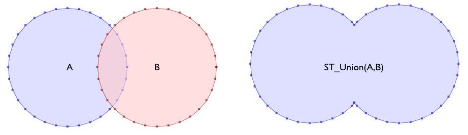
st_unionaggregate which will dissolve boundaries between contiguous polygons.st_union will reduce the size by about 70% for the data sample you provided. Keep in mind though that significant size reduction will only only occur when where your county polygons are contiguous.
If you only need a rough approximation of the area, you can use
st_envelope()to get the minimum bounding rectangle of each county polygon and thenst_union()those together:This approach reduces the size of your sample data by about 98%, but will result in false positive matches if you intersect it with other data.
If you are only using these boundaries to determine if some point/polygon/line data intersects them, you could consider saving the counties directly as postgis geometries in a table and using st_intersects(county_geom,some_other_geom) to determine if an intersection exists between the counties and other features. This will prevent you from needing to load the geojson representation in your application layer at all -just make sure you create a
GIST INDEXon the geometry column for efficient index lookups if you go this route.